QZSS, also known as Michibiki, is a Japanese satellite positioning system composed mainly of satellites operating in quasi-zenith orbits (QZO), servicing the Asia-Pacific region.
From November 2018, it has operated satellite constellation of 4, with another 3 planned.
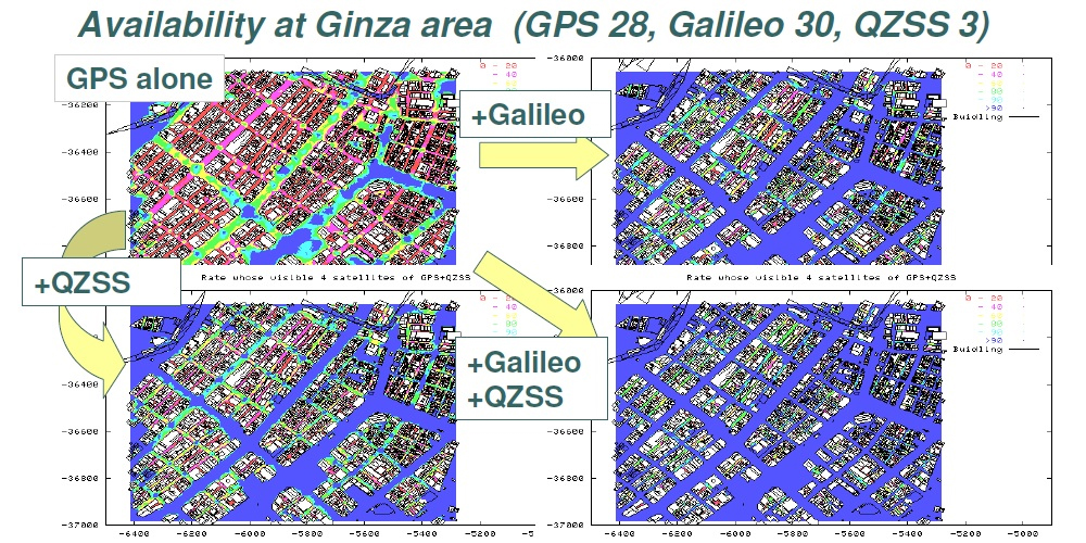
This satellite system was designed to work in conjunction with a standalone GNSS, such as the United States GPS, providing improved positioning performance, as well as reliability in Japan’s numerous cities filled with skyscrapers where only satellites at high elevation can provide signal to GPS devices on the ground.
Compared to standalone GPS, the combined system of QZSS and GPS delivers improved positioning performance through ranging correction data provided through the transmission of submeter-class performance enhancement signals L1-SAIF and LEX from QZSS.
It also improves reliability by means of failure monitoring and system health data notifications. QZSS also provides other support data to users to improve GPS satellite acquisition.
Quasi Zenith Orbit
The QZSS currently operates 4 satellites total, with an additional 3 to be added by 2025.
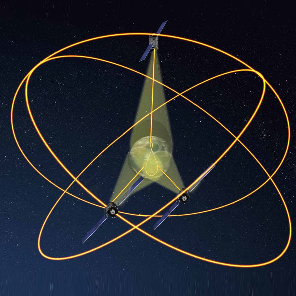
QZSS uses one satellite in geostationary orbit, with the remaining three satellites in a Tundra orbit highly inclined, slightly elliptical, geosynchronous orbits.
Each satellite is spaced 120° apart from the other two whilst in orbit & because of this inclination, they are not geostationary.
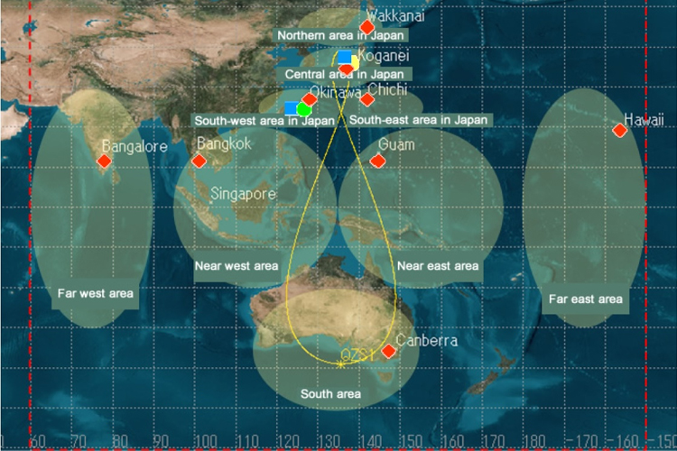
They will not remain in the same place in space. Instead of this, their ground traces are asymmetrical figure eight patterns. In this setup, it is ensured that one satellite is constantly above Japan.

Service Area
The QZSS is meant to be a regional solution, rather than a global one, meaning Europe and the US miss out on the free coverage.
The QZSS service area covers East Asia and Oceania region and its platform is multi-constellation GNSS. The QZSS system is not required to work in a stand-alone mode, but together with data from other GNSS satellites.

QZSS uses one geostationary satellite and three satellites in Tundra-type highly inclined, slightly elliptical, geosynchronous orbits. Each orbit is 120° apart from the other two. Because of this inclination, they are not geostationary; they do not remain in the same place in the sky. Instead, their ground traces are asymmetrical figure-8 patterns (analemmas), designed to ensure that one is almost directly overhead (elevation 60° or more) over Japan at all times.
The space segment consists of three satellites placed in periodic Highly Elliptical Orbit (HEO) and a fourth in a geo-stationary orbit. For the satellites in HEO, the perigee altitude is about 32000 km and apogee altitude about 40000 km, and all of them will pass over the same groundtrack. QZSS is designed so that at least one satellite out of three satellites exists near zenith over Japan.
Configuration
There is a ground and space segment with QZSS.

Ground Segment
The segment on the ground contains a master control station (MCS), multiple tracking control stations (TT&C), laser ranging stations and various monitoring stations.
The monitoring stations network covers the following regions in East Asia and Oceania region
- Stations in Japan (Okinawa, Sarobetsu, Koganei, Ogasawara)
- Stations abroad: Bangalore (India), Guam, Canberra (Australia), Bangkok (Thailand) and Hawaii (USA).
The MSC is responsible of the navigation message generation that are communicated to the quasi-zenith satellite through the Okinawa TT&C station.
Space Segment
Satellites
The space segment is comprised of three satellites placed in periodic HEO (Highly Elliptical Orbit) and a fourth satellite in a geo-stationary orbit.
QZSS ensures that at least one satellite out of three satellites exists near Japans Zenith.
Given the orbit path, each of the satellites appear almost directly overhead for the most part, equaling over 12 hours a day.
The expected operational time of the quasi-zenith satellites is of 10 years, afterwhich they will begin to be replaced. QZS-1 which was the first satellite launched on 11 September 2010, is expected to be replaced by QZS-1R in 2021.
Current
| Name | Status | Launch Date | Decommission Date | Notes |
| QZS-1 | 11 September 2010 | Estimated 2021 | To be replaced by QZS-1R | |
| QZS-2 | 1 June 2017 | – | Upgraded solar panels | |
| QZS-3 | 19 August 2017 | – | Additional S-Band antenna for GEO | |
| QZS-4 | 10 October 2017 | – | Upgraded solar panels | |
| QZS-1R | 2021 | – | To replace QZS-1 | |
| QZS-5 | 2023 | |||
| QZS-6 | 2023 | – | ||
| QZS-7 | 2023 | – |
Satellite Frequencies
The QZS satellites transmit signals which are compatible with the US GPS L1C/A signal, as well as the modernized GPS L1C, L2C signals and the L5 signals.
This minimizes changes that would need to be performed to existing GPS receivers.
| Signal name | QZS-1 | QZS-2 to QZS-4 | Transmission service | Center frequency | |
|---|---|---|---|---|---|
| Block IQ | Block IIQ | Block IIG | |||
| Quasi zenith satellite orbit (QZO) | Quasi zenith satellite orbit (QZO) | Geostationary orbit (GEO) | |||
| One satellite | Two satellites | One satellite | |||
| L1C/A | ◎ | ◎ | ◎ | Satellite Positioning, Navigation and Timing Service (PNT) | 1575.42MHz |
| L1C | ◎ | ◎ | ◎ | Satellite Positioning, Navigation and Timing Service (PNT) | |
| L1S | ◎ | ◎ | ◎ | Sub-meter Level Augmentation Service (SLAS) | |
| Satellite Report for Disaster and Crisis Management (DC Report) | |||||
| L1Sb | – | – | ◎ Will be transmitted from around 2020 | SBAS Transmission Service | |
| L2C | ◎ | ◎ | ◎ | Satellite Positioning, Navigation and Timing Service (PNT) | 1227.60MHz |
| L5 | ◎ | ◎ | ◎ | Satellite Positioning, Navigation and Timing Service (PNT) | 1176.45MHz |
| L5S | – | ◎ | ◎ | Positioning Technology Verification Service | |
| L6 | ◎ | ◎ | ◎ | Centimeter Level Augmentation Service (CLAS) | 1278.75MHz |
| S-band | – | – | ◎ | QZSS Safety Confirmation Service | 2GHz band |
Satellite deployment plan
A satellite navigation system independent of GPS is planned for 2023 with 7 satellites.
Planned Signals
There are 6 planned signals for the QZSS system:
- L1-C/A (1575.42 MHz)
- Designed to be interoperable with GNSS
- increase availability of PNT services.
- L1C (1575.42 MHz)
- Designed to be interoperable with GNSS
- increase availability of PNT services.
- L2C (1227.6 MHz)
- Designed to be interoperable with GNSS
- Improved availability of PNT services.
- L5 (1176.45 MHz)
- Designed to be interoperable with GNSS
- Improve availability of PNT services.
- L1-SAIF (1575.42 MHz)
- Augmentation is submeter-class based
- Compatible with GPS-SBAS.
- LEX (1278.75 MHz)
- QZSS Experimental Signal for High precision Service (accuracy to 3 cm level)
- Compatible with Galileo E6 signal.
